|
WWDC Home Page
Agency Information
 Mission Statement Mission Statement
Directory
Calendar
Commission Agendas & Minutes
Consultant Information
Items Open for Public Comment
Newsletter
Rules and Operating Criteria
Project Application Information
Emergency Water Projects Prog
Send Us Your Comments
Planning Program
Dam and Reservoir Planning
Groundwater Grant Projects
Instream Flow Filings
Current Planning Projects
River Basin Planning
Critical Irrigation Infrastructure
Watershed Studies
Weather Modification
Probable Maximum Precipitation
Water Research Projects
Construction Program
Current Construction Projects
Small Water Projects
Agency Products
Project Reports
Interactive Maps
GIS Data & Standards
Wyoming Reservoirs Status
Irrigation & Water System Surveys
Legislative Reports
Water Mgmnt & Conservation Dir
History of Wyoming Water Law
Water Plan Home Page
WRDS Home Page
|
High Savery Dam and Reservoir
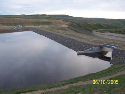
High Savery Dam
|
High Savery Dam and Reservoir is located on Savery Creek. Savery Creek is a tributary to the Little Snake River and is located in the Green River drainage.
The drainage area of Savery Creek at the dam site is 107 square miles and comprises approximately 2.86 percent of the entire Little Snake River watershed area.
The Savery Creek and the Little Snake River watersheds drain a sparsely settled area of south central Wyoming and Northwest Colorado. The communities of
Savery, Dixon, and Baggs, Wyoming are located downstream from the reservoir. High Savery Dam and Reservoir is located approximately 20 miles north of Savery, Wyoming.
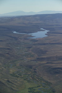
Savery Creek
|
In 1979, the legislature enacted WS 41-2-204, which defined the Stage I, II, and III Projects, as well as Little Snake River "in-basin needs". Stage I and II
generally consisted of water collection, storage and transmission facilities to bring water from the headwaters of the Little Snake River drainage into the North
Platte River drainage and to bring water from the headwaters of the Douglas Creek drainage into the Crow Creek drainage and from the North Platte River
and Crow Creek drainages into the Cheyenne water system. Stage I was completed in 1966. In 1980, the legislature authorized the Stage II Project and, in
the same legislation, instructed the Commission to study the feasibility of constructing storage in the Little Snake River drainage, above the Savery Creek confluence.
This culminated in the construction of High Savery Dam from 2001-2004. The purpose of the project is to serve as an agricultural and municipal water supply,
as well as recreation, environmental enhancement, and mitigation for the Stage I and II trans-basin diversion water supply projects.
Current (7/27/2024 3:00:08) Reservoir Outflow (cfs): 38.1
| General Facts |
| Dam Height | 130 feet |
| Dam Length | 1,100 feet |
| Crest Elevation | 7,320 feet |
| Dam Type | Zoned earth-fill structure |
| Reservoir Storage | 22,432.9 Acre-Feet at Normal Pool |
| Reservoir Surface Area | 482 Acres at Normal Pool |
| Maximum Depth | 130 feet |
| Owner | State of Wyoming |
| Engineer | States West Water Resources Corporation |
| Contractor | Ames Construction, Incorporated |
| Uses | Irrigation, Municipal, Environmental, Recreation |
|