|
WWDC Home Page
Agency Information
 Mission Statement Mission Statement
Directory
Calendar
Commission Agendas & Minutes
Consultant Information
Items Open for Public Comment
Newsletter
Rules and Operating Criteria
Project Application Information
Emergency Water Projects Prog
Send Us Your Comments
Planning Program
Dam and Reservoir Planning
Groundwater Grant Projects
Instream Flow Filings
Current Planning Projects
River Basin Planning
Critical Irrigation Infrastructure
Watershed Studies
Weather Modification
Probable Maximum Precipitation
Water Research Projects
Construction Program
Current Construction Projects
Small Water Projects
Agency Products
Project Reports
Interactive Maps
GIS Data & Standards
Wyoming Reservoirs Status
Irrigation & Water System Surveys
Legislative Reports
Water Mgmnt & Conservation Dir
History of Wyoming Water Law
Water Plan Home Page
WRDS Home Page
|
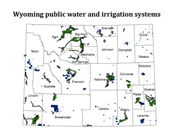
Irrigation and Public Water System Surveys
The Wyoming Water Development Commission maintains databases of irrigation districts and companies, as well as municipal and non-municipal public water systems, in the state of Wyoming. To update the database, a survey is conducted each year alternating between irrigation systems and public water systems. The results from each survey are compiled in reports, which provide important information for the agency's funding criteria.
|
|